
The Providence bicycle diaries
Two avid bicyclists explore dimensions and limits of city’s pedaling ecosytem
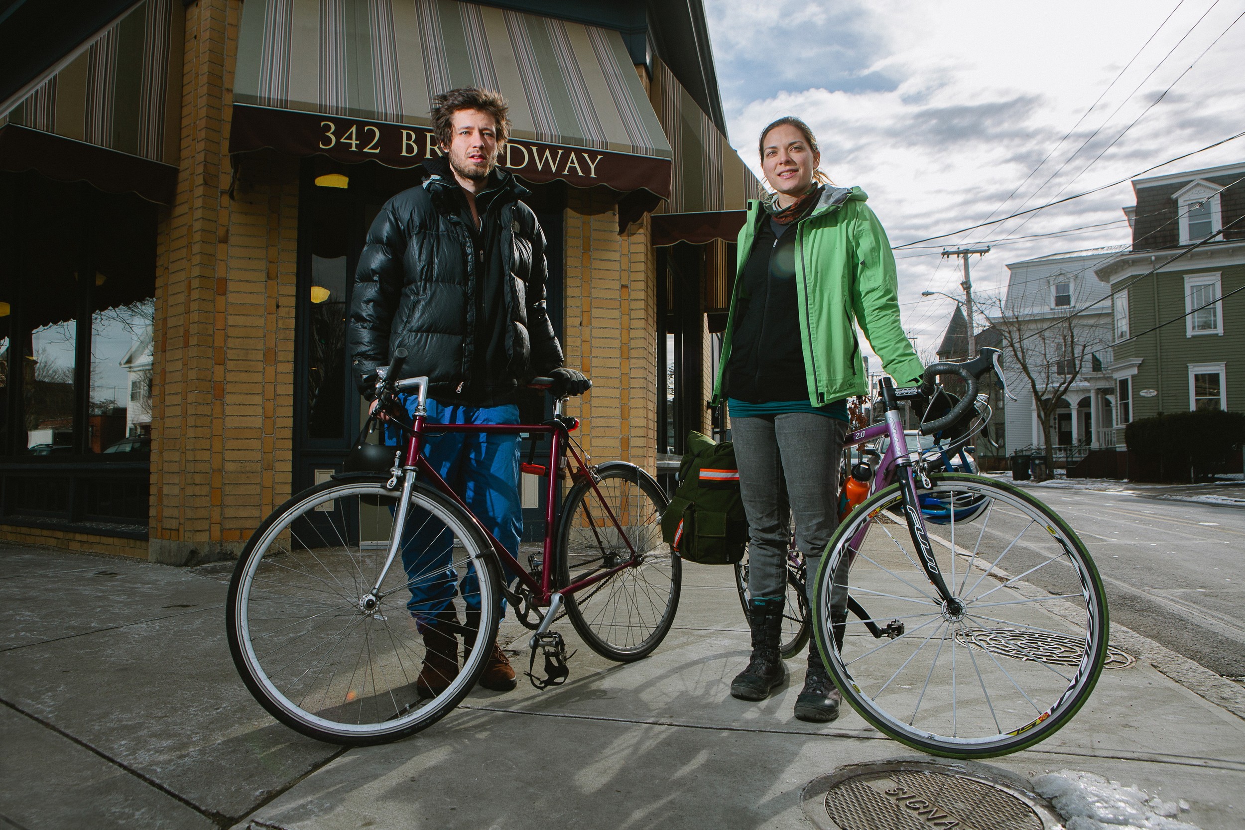
Tally Gilkes-Bower, and Sarah Thomas, in front of Seven Stars on Broadway in Providence, about to begin their bicycle tour of Providence.
The connection between the East Bay Bike Path and Providence is now under construction, resulting in a confusing, sometimes dangerous ride across the Henderson Bridge.
The view from a bicycle is not often considered in making infrastructure investment. Sarah Thomas offers a perspective to begin the conversation how to make Providence a more bike-friendly city, and in the view of David Byrne, in his book Bicycle Diaries, “a more human place to live.”
PROVIDENCE – Bicycling, for many people, is more than a form of recreation. The bicycle is one of the most energy-efficient and cost-effective forms of transportation, and for a city that can be traversed in under five miles, it is an ideal mode of transportation.
Providence already has a lot going for it. Businesses, schools, hospitals, and homes are all located within relatively close distances of one another. A 10-minute walk will take you from one end of downtown to the other, while a 10-minute bicycle ride is likely to bring you into the next town altogether. What Providence lacks is parking spaces – which wouldn’t be in such high demand if more people used alternative transportation modes to get around the city.
Organizations like the East Coast Greenways Alliance, the Rhode Island Bicycle Coalition and Bike Newport have made a continued effort to promote cycling and improve the accessibility and safety for cyclists in the ocean state. Over the last few years, Providence’s road users have seen changes, both positive and negative, to our roads.
One winter day when the temperature had finally climbed above freezing, I met up with Tally Gilkes-Bower, who recently moved to Providence, for a bike ride around the city. Tally is the director of Digital City, a test-bed to create a digital media hub in Rhode Island.
Together, we explored the roads from the cyclist’s perspective to try to find out what is really working and what may need improvement.
We wanted to ask and answer: what is truly facilitating travel by cyclists? What may be preventing someone from even considering cycling as a viable transportation option?
Attempting to answer these questions, Tally and I came up with a few intimidating, confusing and dangerous – or just plain inconvenient – intersections along some of the commonly cycled areas in Providence. This article attempts to document these challenges, exemplify the existing infrastructure that encourages cycling, and invite ideas for innovations or improvements.
The West End
Cranston Street is where the Washington Secondary Bike Path begins (or ends, depending on which direction you’re going). This paved, off-road path connects Providence to Cranston, Warwick, West Warwick, Coventry, and eventually through to Connecticut. People are more likely to ride when they feel safe, and bike paths like this one do a good job of making people feel safe.
However, this path ends rather abruptly at one of the most dangerous streets to ride on. Cranston Street is narrow, with cars parked along both sides. It always has a steady stream of single lane traffic in each direction and is lined with frequent streets, creating potential for more cars to turn into cyclists.
Point Street used to be a two-way street throughout its entire length. Now, heading west on Point Street [where it crosses over Route 95], we are confronted with an obstacle preventing us from legally crossing the highway.
Instead, we are forced to turn right onto the multi-lane service road paralleling the highway until we can cross over the next bridge.
As Tally pointed out, most cars are still in ‘highway mode’ when they get onto this service road, and are still driving at near highway speeds.
The other option many cyclists choose (which is not only illegal in most places but dangerous) is to disregard the “do not enter” sign and ride either on the sidewalk or in the road against traffic.
I’m not sure why Point Street was changed to a one-way street going east, but it really inconveniences cyclists who may be trying to get to the west end or to some buildings of Rhode Island Hospital from Fox Point. The only way to get to the hospital now is to take Eddy Street, which has heavier traffic with not much of a shoulder to ride on.
The East Side
A bike route sign directing cyclists from Wickenden Street onto a side street is unfortunately placed directly behind a telephone pole in such a way that nobody has a chance of seeing it from the road. This would be an easy fix!
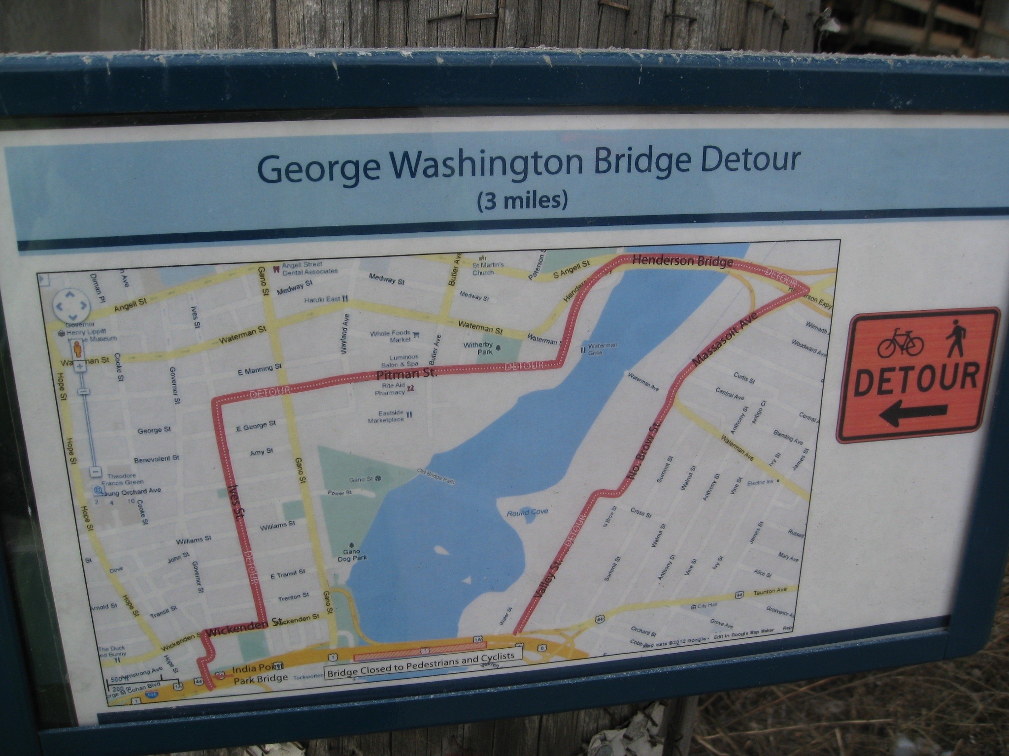
It’s not a big deal though, because continuing straight on Wickenden will also lead to the entrance of the East Bay Bike Path, which is temporarily closed (and has been for almost two years).
Expected to reopen at the end of this summer, I wonder if it will actually happen. Thankfully, there is a helpful sign placed here that maps out a three-mile long detour around the George Washington Bridge and reconnecting with the bike path in East Providence.
Tally and I rode to the Henderson Bridge, which is where the detour to the East Bay Bike Path leads us. From River Road, the entrance to this bridge is basically an inconspicuous gap in the fence along the tree-lined road. The bridge itself seems more like a freeway, and I never would have dared to ride on it had I not known it was the right way to go to get to East Providence. It might be a good idea to add a sign here to let people know that it is a legitimate way to access the bridge, although it’s probably still too scary for many commuters.
Downtown
The intersection at Exchange Terrace and Memorial Blvd can be incredibly intimidating to any vulnerable road user, whether a new or seasoned cyclist. Coming from the east, the cyclist wishing to go straight or turn left must be in one of the middle of four lanes in order to end up in the right position on the road once safely through the intersection.
Some cities paint bike boxes at tricky intersections indicating to traffic that cyclists are legally allowed (and supposed) to be in this space. This Providence intersection would be a great candidate for something like that.
Tally and I were only able to cover a small area of Providence that day, but this article will hopefully be a good start to get people thinking about how road infrastructure affects cycling, and how it can be improved to increase accessibility and encourage cycling. Providence is a small city, which is excellent for riding bikes – not so much for cars.
Sarah Thomas is a native Rhode Islander who lives in Providence with her boyfriend, Dallas, whom she met after each of them had simultaneously ridden their bicycles to New Orleans from opposite coasts of the United States.
Having grown up with a mother disabled from Multiple Sclerosis, Sarah began cycling when she was 13 to raise money for the MS Society.
She built her first bicycle during her last year of undergrad in Montreal, and has been devoted to promoting cycling as a mode of transportation ever since.
For four years after undergrad, Sarah worked as a Biological Safety Specialist for Brown University while earning her master's degree in Environmental Studies, focusing on how to encourage bicycle commuting.
Upon leaving Brown, she became a pedicab driver in Newport and left Providence at the end of the season to bike around the world (which hasn't been completed yet). To document her cycling adventures, Sarah maintains a blog at www.nomadiccycling.com.


